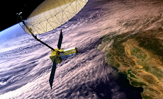
In what could be seen as a big breakthrough for India, a NASA scientist on Monday announced that two of the World's most famous Space Agencies, NASA and ISRO, will come together to launch the NASA-ISRO Synthetic Aperture Radar (NISAR) mission.
Touted as the biggest collaboration between the two space agencies yet, the mission basically deals with building a 2,600 kg satellite that will "effectively make a time-lapse movie of the earth" while also keeping a close tab on the disturbances in the ice-sheet collapses, natural hazards and ecosystem.
NASA and ISRO first collaborated in the year 2005 during the Chandrayaan-I mission. During the mission, an eight-kilogram Moon Mineralogy mapper from NASA accompanied the mission, resulting in the "joint-discovery" of water on moon.
NASA was initially thinking about doing the mission all by itself or collaborating with either Canada or Germany. It was only in the year 2011 that NASA started talking to ISRO for the mission. According to Alok K Chatterjee, Mission Interface Manager and Launch System Engineer of NISAR project, Jet Propulsion Laboratory (JPL), NASA, the NISAR mission is the biggest collaborative effort ever undertaken by the two agencies.
Chatterjee was recently present in Gujarat Science City for an 'outreach event' with other US-based scientists associated with the mission— including NISAR project scientist Paul A Rosen, Mark Simons, Ian Joughin, Scott Hensley, Paul Siqueira and Piyush Agram.
ISRO and NASA have very different roles to play during the mission. While ISRO will be providing the "spacecraft bus", S-band SAR payload and the launch vehicle, NASA, on the other hand, has the responsibility to provide the L-band SAR and the engineering payload that will cost over USD one billion. The mission is expected to be launched in 2020.
[caption id="attachment_102530" align="aligncenter" width="440"]
According to NASA, the NISAR project is currently in a "formulation phase”, which means they're just one step away from start building the actual hardware for the mission.
"This mission aims to create the world’s largest freely available remote sensing data set. It will create one petabyte of raw data every year, said NISAR project scientist Paul A Rosen.
The satellite being designed for the mission is being designed to function for a duration of 5-10 years. According to sources, the data collected form the mission could be used by the scientists to create models that could help in predicting changes in Earth’s topography.
We wish all the very best to ISRO and NASA for the mission. Great going, INDIA!


 IndianWeb2.com is an independent digital media platform for business, entrepreneurship, science, technology, startups, gadgets and climate change news & reviews.


